Journal of Liaoning Petrochemical University

Journal of Liaoning Petrochemical University ›› 2024, Vol. 44 ›› Issue (3): 89-96.DOI: 10.12422/j.issn.1672-6952.2024.03.012

• Information and Control Engineering • Previous Articles    

Research on Extraction of Land Use Status Information from Remote Sensing Images Based on CA-Res2-Unet

Caihua SUN(), Yang CAO(), Hongfei YU, Xuejian CHEN   

  1. School of Artificial Intelligence and Software,Liaoning Petrochemical University,Fushun Liaoning 113001,China
  • Received:2023-11-10 Revised:2023-12-20 Published:2024-06-25 Online:2024-06-17
  • Contact: Yang CAO

基于CA-Res2-Unet的遥感图像土地利用现状信息提取研究

孙才华(), 曹杨(), 于红绯, 陈雪健   

  1. 辽宁石油化工大学 人工智能与软件学院,辽宁 抚顺 113001
  • 通讯作者: 曹杨
  • 作者简介:孙才华(1999-),男,硕士研究生,从事遥感图像处理、计算机视觉方面的研究;E-mail:sch1711@163.com
  • 基金资助:
    辽宁省教育厅基本科研项目(LJKMZ20220754)

Abstract:

The combination of remote sensing image information extraction and artificial intelligence algorithms is an important technical tool for land use status survey, monitoring and management in land resources and environmental departments.Aiming at the problems of insufficient spatial information localization and inaccurate multi-scale target feature segmentation generated by U-net in remote sensing image extraction, a CA-Res2-Unet model incorporating an attention module into the head of Res2Net to replace the coding part of U-net is proposed, which aims to enhance the spatial localization and multi-scale feature information segmentation capability of U-net.Experiments were carried out on mainstream networks and improved models through the WHDLD public data set and the self-made data set of Shenfu New District. The results show that compared with the basic model, OA, MIoU and F1indexes of the experiment on the WHDLD public data set and the self-made data set of Shenfu New District increased by 0.92%, 2.00%, 1.58% and 1.18%, 2.87%, 1.91%, respectively. The visual effect and quantitative indexes of the proposed method are superior to other mainstream semantic segmentation networks, which can provide scientific basis for the investigation of the status quo of regional land use and the decision-making of relevant departments.

Key words: CA-Res2-Unet, Remote sensing images, Status of land use, Spatial information localization, Multi-scale targeting

摘要:

遥感图像信息提取与人工智能算法结合是国土资源及环境部门进行土地利用现状调查、监测和管理的重要技术手段。针对U-net在遥感图像提取产生的空间信息定位不足和多尺度目标特征分割不准确的问题,提出了一种在Res2Net头部融入注意力模块取代U-net编码部分的CA-Res2-Unet模型,旨在增强U型网络的空间定位和多尺度特征信息分割能力;通过WHDLD公共数据集和沈抚新区自制数据集,在主流网络和改进模型上进行了实验。结果表明,该模型较基础模型U-net在WHDLD公共数据集和沈抚新区自制数据集上实验的整体准确率、平均交并比和mF1分数(各类F1分类的平均值)三个评价指标分别提高了0.92%、2.00%、1.58%和1.18%、2.87%、1.91%,所提出方法的图像分割视觉效果和各项定量指标均优于其他主流语义分割网络,可为区域土地利用现状调查和相关部门决策提供科学依据。

关键词: CA-Res2-Unet, 遥感图像, 土地利用现状, 空间信息定位, 多尺度目标

CLC Number: 

Cite this article

Caihua SUN, Yang CAO, Hongfei YU, Xuejian CHEN. Research on Extraction of Land Use Status Information from Remote Sensing Images Based on CA-Res2-Unet[J]. Journal of Liaoning Petrochemical University, 2024, 44(3): 89-96.

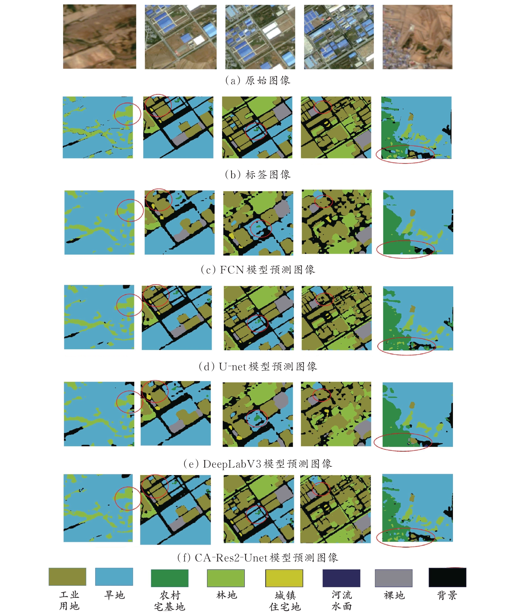
孙才华, 曹杨, 于红绯, 陈雪健. 基于CA-Res2-Unet的遥感图像土地利用现状信息提取研究[J]. 辽宁石油化工大学学报, 2024, 44(3): 89-96.